FLAT EARTH ~ All Maps are Liars ! (2-of-3)
About | Information | History | Online | Facts | Discovery
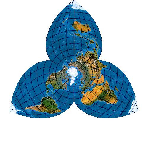
This video was created to give some examples of assumptions which go into cartography (making maps), and how we can possibly change some of the rules or assumptions to get an entirely different matrix in which to plot known distances on a chart. I'm certainly no cartographer, but by assuming the North Pole (for example) is a single point is an integral assumption which appears to find its way into all maps. I'm not saying this is the key to mapping the plane accurately, I'm just illustrating the point that we should question fundamental assumptions which, when modified even slightly will change the matrix of the grid, and therefore will change the entire layout of the map. Hopefully you'll understand the point I'm making by the end of the short series. Zetetic Astronomy AudioBook Playlist: https://www.youtube.com/playlist?list=PLfdNh0aH8F1epyQnCCu1oGw15eDi_YW7I Antarctic / Arctic Treaty Petition: http://www.thepetitionsite.com/336/039/559/the-sovereign-peoples-movement-to-abolish-the-arctic-antarctic-treaties/
Comments
-
Your new map is tearing apart the mediterrainian ocean,which is totally wrong and absurd.
-
good stuff brother but remember flat earth has more than one sun. look it up. it would explain alot of things and a new model is needed.
-
love your video's love your perspective ,
-
You are Right Making A Map is not Easy it Requires efforts , Of course Earth is Flat , I tried to know the True Shape of Suez and Aqaba Gulf because I work on Ship sailing this Destination , and I reached that No doubt the Suez And Aqaba on Red Sea Are Gulf Because simply I can see the Both Sides of Shores BUT Suez Gulf is Wider and Taller Than Aqaba gulf No Doubt about all of that BUT their True Shape Or Their True Direction What look Like Exactly on Real and on Supposed True Map I really Can't Reach to that , in Official map make the Two gulfs shape look like Goat horns And That's weird
-
http://www.boehmwanderkarten.de/kartographie/netze/world_bartholomew_star_classic_3_23$5_-30.jpg
I prefer this flat earth map. Close to what you present. -
I would like to sign your petition but how do we know that you won't sell our information. I know you said we can sign it anonymously but it would have more impact if we were up front. Also as TigerDan pointed out there may be negative consequences like us being put on a list by the Homeland Security. I'm not trying to bust your chops I just don't know these answers. You can see that I have been disagreeing with TigerDan and have ripped him a new one for his BS. But the truth is that in his last video, though I think it was wrong for him to use fear to make his point, he did have a point about being put on a petition. That is about the only good point he made though it has nothing to do with evidence of a planet globe or ball.
-
Here are some compelling arguments against TigerDan`s claims !!! by Michael Helmick, me and others.
Bottom Line.......... LAN's more capable 787_8 can't make the nonstop. LAN said it can't, and they want that nonstop from Sydney to Santiago. The 787_8 is listed with a range from Boeing at 9,200 miles, but the Google distance says it's only about 7,100 miles. Somethings off here.
Here is the Article from LAN, if you want to verify this!
http://www.ausbt.com.au/lan-considering-direct-sydney-santiago-flight-on-boeing-787-9
Sam Chui and NASA. His Plane could not have made a nonstop. BS and others on his video called BS.
http://stickers.athrust.com/photo/37528-nasa
It all summarized here ;
https://www.youtube.com/watch?v=RTukjobtLiE
Video by Michael Helmick -
Hey, Jon, the guy that ambushed you with his sidekick PhD has quit again! I guess you won't be invited back now for a fair debate!
-
So, in short... you slopped outlines of continents onto an ellipse, ignored antarctica, and ignored geometry and call it a map.
-
will post this message in FLAT EARTH VIDEOS as much as i can, YOU MAY HELP TOO .. :)
i am hoping all the leaders who post flat earth videos on you tube can come together and put up a common website where we can all submit our names/country of origin so we can signify our support for the truth and be counted. it would be very encouraging for everyone to know our vast and growing number. -
great job mr. morgile. mr thrive and survive has had training in cartography....i can't draw a straight line so ....i'll continue to "work on the moon".....thanks
-
Good Point on the sun's path. Reviewing the midnight sun time-lapse, I was mistaken about the sun from the camera's location skimming the horizon both east and west. The video appears to have the the camera located at a spot where the sun only skims the horizon in one direction. The rest of its elongated path is in the proximity of the camera that results in only one location getting close to doing a "sun set."
-
Did you know that "SOME ONE" is already mining diamonds in Antarctica?? And God only knows what else they're pillaging from there....
I think the leading nations of the world are already raping the natural resources of Antarctica, and getting phenomenally rich off of the materials, all-the-while cutting out the corporations!! Seriously, I certain that there is way more activity going on in Antarctica then any of us can possibly imagine!
http://www.dailymail.co.uk/sciencetech/article-2526295/Are-diamonds-lying-beneath-Antarctica-Precious-stones-lurking-ice-no-one-them.html -
Why didn't you rotate the continents and put the Prime Meridian in the UK at Greenwich?? I think your data would be better/more accurate if you did....
-
Fossil fuel is bullshit, concocted by J.D. Rockefeller and long dis proven, simply by the depths that drilling has gone to. Peak oil is a fraud and there are wells capped in the 1940's, that have subsequently refilled since that time.
-
if there will even be any history books of the future
-
why do all the continent's names begin with an A? weird right? lol
-
I think u should go down in the history books of the future morgile =)
14m 57sLenght
151Rating